WUI Fire Evacuation and Sheltering Considerations — Assessment Planning and Execution

DETERMINING DECISION ZONES
Dividing communities into decision zones based on fire arrival time helps guide timely, targeted action. With clear triggers and everyday language, this approach ensures residents and responders know when and how to act-before the fire arrives.
Designing the Decision Zones
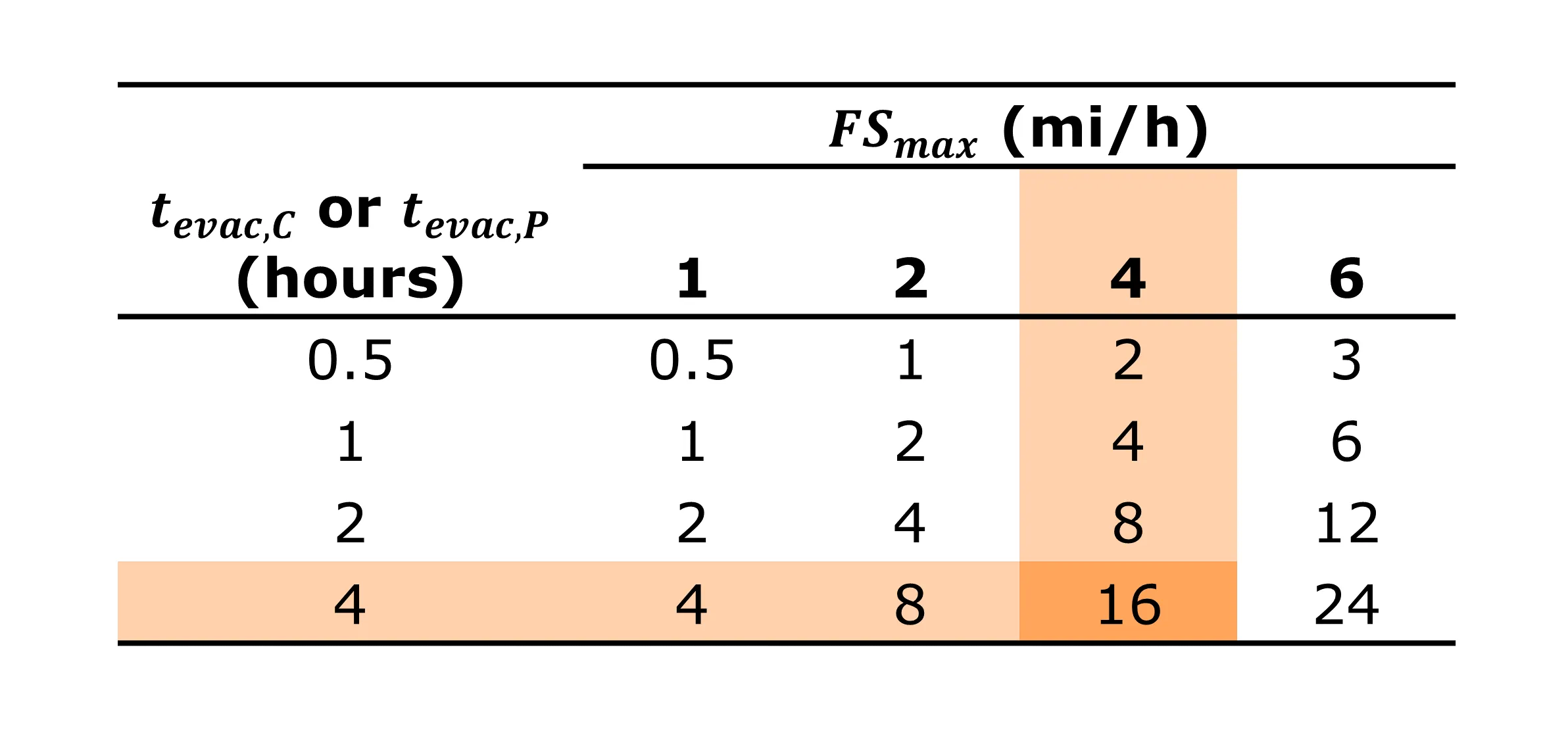
Calculations of distance from the inner boundary of the green zone and the boundary of an intermix community based on a range of fire spread rates and different evacuation durations. (tevac is the time required for complete or partial community evacuation)
The widths of the decision zones, dzone, are determined by estimates of fire spread distance covered during the time required for evacuations:
dzone = FSmax x ITS
where FSmax is the fire rate of spread and ITS is the time required for community evacuation. The resulting number corresponds to the minimum distance away from the community where there is enough time to conduct the evacuation or action.
The design of the zone is accomplished using the following steps:
- Determine the ITS duration.
- Determine the expected fire spread rates based on fuels, wind, and topography. Remember that spot fires can effectively increase the fire spread rate by starting new fires miles ahead of the main fire front.
- Determine the inner most part of the zone based on ignition location, expected effective fire spread rate, and community evacuation specifics.
- Determine the outermost zone. Because the potential for rapid fire spread exists during many severe wildfire and WUI events, attention should be placed on quantifying the expected FSmax.
If a community requires two hours to evacuate (partially or fully, depending on the scenario) and the expected fire spread rate FSmax is 4 mi/h (6.4 km/h), then the red/green zone boundary should be set at 8 mi (12.8 km) from the boundary of the community. Considerations such as fuels along egress arteries, long range spotting, and other conditions that may impact different parts of the community evacuation still need to be addressed.
The range of fire spread rates and evacuation times listed in the table are not unprecedented. Recent WUI fire events have been within these bounds.
The immense size and distance further emphasizes the importance of advance planning for the use of TFRAs in the event a community is subjected to rapid fire spread.
A 16 mile radius circle encompasses more than 500,000 acres.
Decision Zone: ignition location, rate of spread, direction and community intersect
Uncertainty in fire spread rates can be addressed by increasing the width of the decision zones, which can serve as engineering safety factors. Additionally, the zone widths can be used to establish temporal fire containment thresholds. Rapid fire spread under high winds or dry conditions can cause a fire to cover more than a mile in 15 minutes. Quick containment depends on factors like the time of day (which affects aerial suppression availability), detection time, accessibility, staffing, and environmental conditions. For example, if an ignition in the Green Zone cannot be contained, including spot fires, a full community evacuation should be considered before the fire reaches the boundary of the Green and Red Zones. While there is a chance the fire may be contained in the Red Zone, that likelihood should be weighed against the risk of long-range spotting and other conditions that could hinder containment. The potential for spotting from the Green Zone into the Red Zone with limited containment prospects should also be taken into account.
The outer edge of the Red Zone indicates where an evacuation might not be completed before the fire reaches the community. An ignition in the Red Zone that has the potential to be contained presents a difficult decision. If the fire cannot be contained, there will be insufficient time to evacuate the community safely. Therefore, evacuation procedures should generally be activated except in specific situations where quick and easy access makes containment more likely. These special situations should be clearly defined, as even small reductions in first responder resources could lead to the fire affecting the community during evacuations.
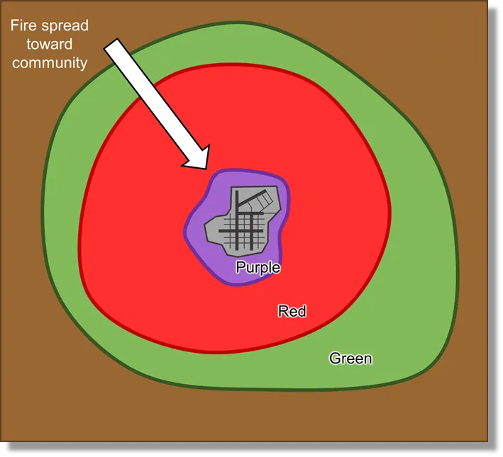
The innermost Purple Zone represents locations where fires will have limited impact on the community as a whole and only partial evacuation or partial shelter-in-community may be necessary. This includes scenarios where only a small fraction of the community is impacted, owing to local conditions and the layout of the community with respect to the fire spread. If such scenarios do not exist or cannot be reliably developed for a particular community, then a Purple Zone does not have to be used, and the inner boundary of the Red Zone will abut the community boundary.
UNCERTAINTY AND SAFETY FACTORS
Increasing the width of the decision zones can account for uncertainties in expected fire spread rates and add a safety factor to the evacuation.