WUI Fire Evacuation and Sheltering Considerations — Assessment Planning and Execution
Camp Fire Egress Artery Closure with Time
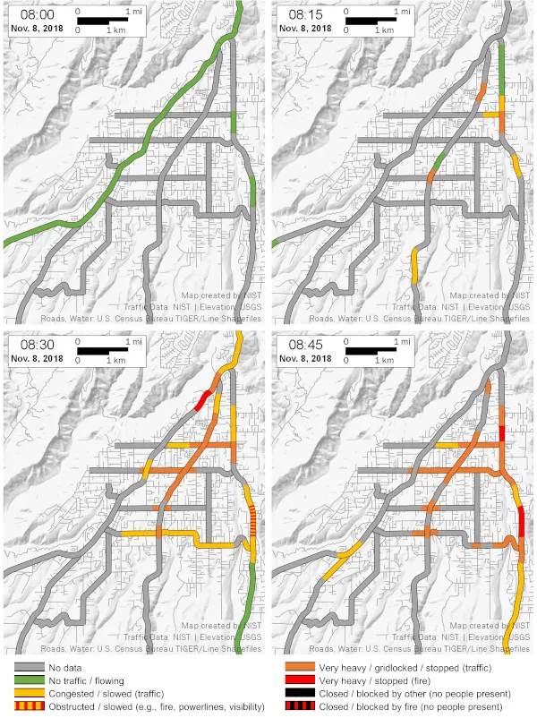
The Camp Fire impacted evacuation of Paradise, specifically the traffic, in two distinct ways. Firstly, the ember showers that resulted in 30 spot fires throughout Paradise before the arrival of the main fire front resulted in the need to evacuate the entire community simultaneously. Secondly, the fire front, which extended along almost the entire eastern edge of the community, resulted in rapidly deteriorating conditions in the eastern part of town, followed by the central and western parts.
The combination of traffic gridlock and fire impacts resulted in multiple burnovers that entrapped evacuees and restricted evacuation of civilians and ingress of first responders. The rapidly deteriorating egress conditions illustrate how difficult it is for civilians to travel though highly congested areas after a fire has impacted a community. The map figures illustrate how quickly the traffic conditions deteriorated in the hour after the first spot fire reached the community.
At 08:00, traffic was flowing throughout Paradise (indicated by green segments) as the first spot fires ignited in eastern Paradise. By 08:30, traffic throughout Paradise had significantly deteriorated (indicated by yellow and orange segments), and fire overtook traffic both on Pentz Road and upper Skyway (indicated by the red segments). These two burnovers significantly affected traffic flow out of and through Paradise.
Each of the five egress arteries out of Paradise were closed due to fire at least once during the evacuations on November 8. At 09:00, the first evacuation route to close was Pentz Road (the easternmost artery). Conditions continued to deteriorate and between 11:30 and 13:00, three of the four southbound egress routes were closed simultaneously.