WUI Fire Evacuation and Sheltering Considerations — Assessment Planning and Execution
Gathering Evacuation Specific Data
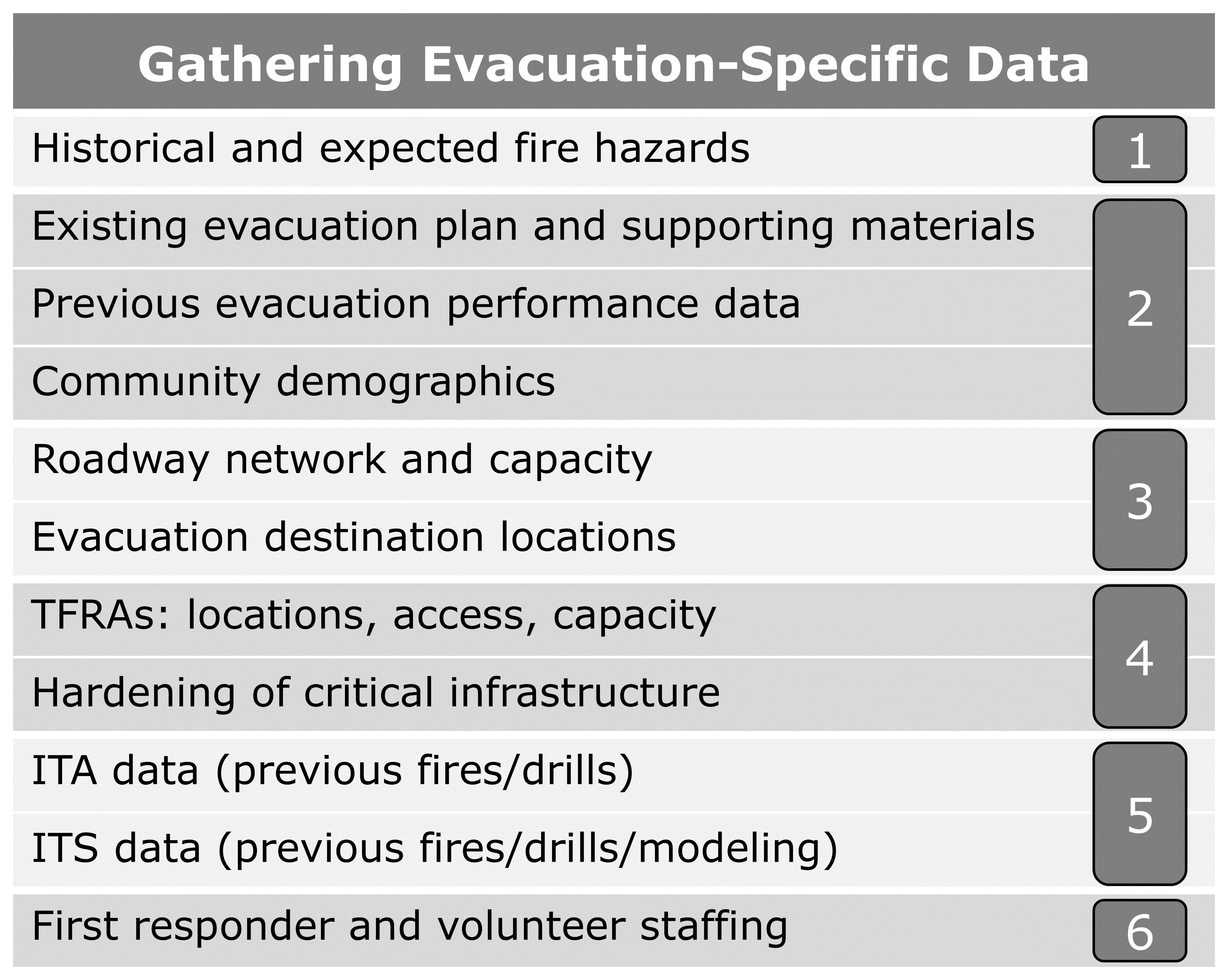
#1 Data about vegetative and built environment fuel densities will provide context of possible fire behavior, particularly when viewed together with fire history, topography, and weather statistics on high wind events.
This information can then be reviewed in the context of egress and ingress arteries. Discussion with the community and regional fire agencies will help identity which fires and under what conditions fires may get out of control.
#2 Information on the time needed to evacuate the community should be collected from any previous evacuations. If limited data exists on community evacuation, an evacuation drill may provide critical information for the development of the community evacuation plan.
Demographic data and information regarding senior citizen and medical care facilities will facilitate the identification of susceptible populations and help identify possible evacuation solutions.
#3 The road network and capacity are driving factors in the overall evacuation process, including route choice and total duration (ET). Details of the road network, fuel, topography, and fire history can provide context for evacuation hazards and can be used to identify potential burnover locations and bottlenecks.
Destination locations for evacuees should be identified, and road capacity and potential fire hazards should be documented for the entire travel corridor from the community. Depending on the road network, remoteness of the community, and surrounding fuels, roadway capacity may need to be assessed well beyond the community boundaries. Gridlock and road constrictions can occur many miles away from the evacuating community and can result in traffic getting backed up all the way to the community.
#4 One of the key data collection efforts will be the identification and documentation of TFRAs. Identifying, marking, and communicating the location and use cases of TFRAs is essential to informing the public and first responders what to do when evacuation out of the community will not be safe. Identification of TFRAs should also include provisions for maintenance, signage, access, capacity, and final evacuation procedures.
Information on the status and hardening of critical infrastructure should also be collected. This includes any structure hardening and fuel treatments around critical infrastructure like water pumping stations, telecommunication towers, and electrical distribution equipment. The purpose of collecting this information is to identify infrastructure hardening needs and to understand the potential failure of these critical systems. Hardening of key infrastructure systems is part of developing a reliable notification and evacuation plan.
#5 Determining the duration of ITA and ITS are cornerstones to establish decision-making criteria for evacuation plans.
An evacuation drill may provide an opportunity to collect reliable data to identify these times. Drills will also engage the public and mutual aid departments and build response "muscle memory." Practicing the implementation of complex evacuation tools, such as contraflow (all lanes one-way outflow), will benefit both first responders and evacuees when they are used during a real event.
Evacuation of part of the community will provide useful information on minimum evacuation times; however, it may not necessarily identify critical traffic flow/congestion issues that may only manifest at higher traffic flows. The primary purpose of the evacuation drill is to determine minimum ignition to safety timelines without any direct or indirect impacts from fire.
Ignition to notification activation time can be determined in one or more separate first responder exercises.
#6 First responder staffing, availability, response timing, and capacity of local and mutual aid resources will all impact evacuation coordination, execution, and civilian life safety.